|
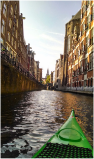
After enjoying the Rotte River trip described on Johan's Kayak Site, I decided to contact Johan himself. I sent him an email with some questions about kayaking in the Netherlands and to see if he wanted to go for a paddle. Apparently I'm not the first person to have this idea, because he later mentioned that two other avid kayakers (a New Yorker and Californian) had inquired similarly. We took advantage of one of the last sunny weekends and paddled around the center of Amsterdam. Over the course of the day, we paddled most of the three routes described on his Amsterdam route page.
Click "Read More" to hear about the trip and see some classic Amsterdam canal photos. |
We started our trip just outside of the city, on the Amstel River at the Utrechtse Bridge (see map below). There was free parking just down the road. We paddled right, under the bridge and towards Amsterdam. This stretch of the trip is on the wide Amstel River, so we stuck close to the side to avoid larger ships and motor boats. Many people were out enjoying the sun in a variety of watercraft. We pulled over for coffee in one of the few locations where it is possible to dock a boat in the center of the city (most of the canal walls are too high).
As you can see on the map below, Amsterdam is series of half-circle canals radiating out from the center, where the harbor and train station are located. To get into the maze of canals, you pass through a set of sluice gates across the river. Johan said that these close at night to encourage flushing of dirty canal water. Each gate has a green/red light that indicates whether or not you can pass going in your direction. From there, we began a complicated maze-like tour of the city, which I attempted to recreate in the map below. I can guarantee, however, that some parts of the map are not exactly the route we took!
The center was lively, with tour boat traffic jams, parties on the bridges, and happy high tourists sitting with feet dangling in the canal. We saw no other kayaks or canoes all day, and garnered much attention from drunk students in party boats. We paddled by the back of the flower market, the train station, and some other landmarks, but the canal to the red light district was closed for construction. The connections between concentric canal rings were often low, dark, and narrow tunnels, so we had to be careful to avoid any motor boats coming in the opposite direction.
After exploring the center of the city, we moved out to some of the peripheral canals, where we had lunch on a dock adjacent to a park. We added one more loop towards the southeast side of the city, where the canals were wider, bordered by trees/parks, and the buildings were more modern.
Click on the photos below to see the full-size versions with captions...
Distance: ~15.5 miles (25 km)
Duration: ~6 hrs, including coffee + lunch break


 RSS Feed

